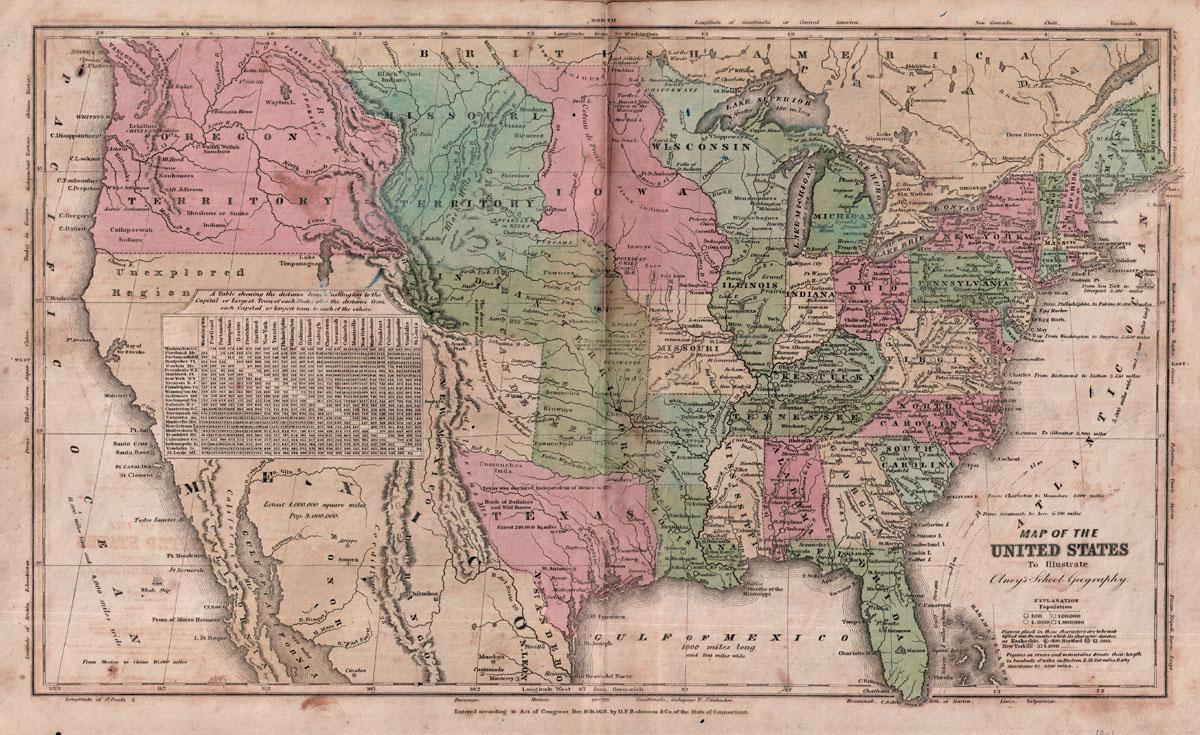
Content Warning

My last map has a box labelled 'Fig. 175B'. Just a reminder that these are placeholders for figure numbers in a future project which I will be talking about later in the year.

Let's zoom in on that boxed area. This map shows the landing ellipse shown in a 2009 publication. A smaller box zooms in towards the landing site. A wrinkle ridge is just visible within it.

#maps #moon #luna17 #lunokhod1

Content Warning

Finally that zoom-in sequence leads to this. Box A in the previous post refers to A here, which takes us to B with the lander itself. Box C in the previous post refers to box C here and the link to D, the rover's final parking place. Tracks from Lunokhod's wheels are visible around Luna 17 and the parked rover. We will be following the traverse in a set of maps like the Apollo EVA maps. But first, let's consider how we know where Luna 17 landed. #maps #moon#Luna17#Lunokhod1

Content Warning

Zooming in again we see the ridge very clearly. I will have something to say about it soon. Among the scattered craters are two more boxes. The lower one shows the position of the lander. The upper one shows the final resting place of the rover. I make sequences of maps like these so people can easily find a small spacecraft in a large image (LRO NAC images are 50,000 pixels long and 5000 pixels wide, that's a lot of pixels to search through).
#maps #moon #luna17 #lunokhod1

Content Warning

Now it's very clear where Luna 17 landed. we have LRO images good enough to show the lander and rover and the wheel tracks. But what did we know before LRO? My first Moon atlas came out before LRO (so it was swiftly rendered out of date and some of my speculation was shown to be wrong). This illustration shows what I thought about the landing site in about 2005 when I was doing that work. Tracking and orbit data gave us a position accurate to within about 10 km. #maps #moon#Luna17 #lunokhod1

Content Warning

Here is that Soviet-era map. My shaded relief version, based on this, shows a large crater near the middle - the largest one in the map. Naturally I tied to match it to the orbital data. But it doesn't really exist if you check the LRO data, so I can use that as an excuse for not getting it right. Maybe it was a very subtle depression rather than a distinct crater. #maps #moon #luna17 #lunokhod1

Content Warning

In 1976, The New Yorker magazine published Saul Steinberg's famous cover meant to show the perspective on the world of the average person on 9th Ave in NYC. Its impact was immediate and still continues today, as it wasn't just a specific joke, but a lens by which you can portray the local perspective of anyone. In a paper publishing next month we look at Saul Steinberg's projection and how its a culmination of regionalism in geography.
#maps #history #nyc #map #geography

Content Warning

Next, Utopia, where Viking 2 landed in 1976. Unlike all those other names, this is not ancient and comes from Thomas More's book of 1516. It literally means 'nowhere' and is used for a perfect place or society (maybe so perfect it couldn't really exist). In the book it was an island out in the Atlantic near the Americas.This name is not on Schiaparelli's map and probably comes from Flammarion and Antoniadi's map of 1900. #maps#Mars

Content Warning

After that rather long excursus into Martian nomenclature we return to the sequence of Mars maps. Looking back, we saw maps of light and dark markings, at first barely glimpsed through telescopes, but evolving into quite sophisticated drawings - Green's map is quite realistic though others seem more sketchy. Schiaparelli saw lines ('canali') and Proctor rendered them as rivers. From 1890 to about 1930 many maps showed canals, which we now discount. #maps#Mars

Content Warning

In the middle of the 20th Century canals had fallen into disfavour. Typical maps of the 1950s, such as the International Astronomical Union (IAU) map drawn by Glauco de Mottoni y Palacios in 1957 as a key to official nomenclature, showed broad light and dark areas similar to Green's map. Here it is stripped of names (by cloning) and transformed to my common projection. Nothing suggesting topography or geology is visible. Don't be fooled by assertions that some people saw craters. #maps#Mars

Content Warning

That last map was drawn in the year of Sputnik. Direct exploration by spacecraft was not far off, so NASA needed a new map. The job went to the US Army and Air Force, who both had large mapping agencies and were gearing up for Moon mapping. I will show the Air Force map. You can see it here:

https://www.lpi.usra.edu/resources/mars_maps/MEC-1/

Look at that - it has canals! So did the less aesthetically pleasing Army maps. It's a curious footnote of Mars mapping history. #maps#Mars

Content Warning

Here I add my manipulated version of it for easier comparison with the others. Look at the original - it's north up, not south up. The old astronomical convention was dropped. Longitudes go from 0 to 180 east and west from the prime meridian (still using the 1840 version of zero longitude). Our familiar names are on display. Compare Syrtis Major's longitude here and on the previous map - this one is 10 degrees too far east. Oops! #maps#Mars

Content Warning

No - Schiaparelli saw Mars like this - with south at the top. Until the dawn of the space age most planetary maps were drawn with south at the top as seen in an inverting astronomical telescope. Only when maps might be used for direct physical exploration did the convention change to avoid potential confusion. Rather than turn our screens upside down, let's do a 'rotate 180 degrees' in Photoshop. Simples! #maps#Mars#Hubble

Content Warning

Now we need to look back in time to the classical understanding of the world. How better to do that than with Ptolemy's map of the world known to him at the time? None of Ptolemy's maps survived into the medieval world, but his list of places - a sort of gazetteer - did. 8000 places with his estimates of their latitude and longitude, from which his maps have been reconstructed. See the similarity? No, nor do I, but Schiaparelli found a way to link them. #maps#Mars#Ptolemy

Content Warning

And here it is. A Hubble image of Mars and a 19th Century drawing, both with south at the top. Astronomers had observed a roughly circular marking with a central dark spot. Schiaparelli made it the place where Helios would begin his journey over the planet, distributing names as he went. He named it Solis Lacus, the Lake of the Sun. The modern feature Solis Planum is inside it. #maps#Mars#Shiaparelli

Content Warning

I answered my first map question in a separate post. Back to Herschel: his map has no coordinates but coordinates can be approximated. I projected the Herschel map into a cylindrical projection and then into two equator-centred azimuthal projections making the best match I could to modern coordinates. My intention was to take a variety of historical and recent maps in different projections and display them all in a common format for comparison. #maps#Mars#Herschel

Content Warning

Here is Herschel's actual map (left). I compare it with a mid-20th Century map in the same projection (azimuthal, extending from the south pole at centre to the mid-latitudes in the northern hemisphere). There's no coordinate grid but it vaguely resembles the more modern map. It's the first map of Mars, but not the first map of another planet. Anyone care to speculate who made the first map of another planet, and which one? #maps#Mars#Herschel